 |
| Cruise ships and Canada |
 |
| The glorious weather brought out the clam hunters |
I left Sally’s house early. I wanted to get down to the
Lacey, Washington ShopKo to pick up my foot support. I am really fortunate that
I have Jesse as a friend, who was willing to spend the time and effort to find
things like this for me. It took a few hours and a number of phone calls, but
he was able to find the only Slimline Ankle Brace, apparently, in the whole
Northwest.
 |
| Cape Flattery |
 |
| Looking down at the most northwest point in the U.S. |
I picked up the brace and looped back up the interior drive
of the Olympic Peninsula. What a glorious drive it was. It was the first day in
quite a few that it was sunny and warm, so I took my time and wound up and
around to Olympic National Park. When I got to the northern visitor center, I
talked briefly with a ranger, a young woman, who was not much help in the way
of suggestions for hikes or areas not to miss.
 |
| Looking out from Cape Flattery |

Tara, my new friend from LARC, had suggested that I not miss
the Hoh Rainforest, so that was high on my list. The rainforest, though, was
completely around the park, and I wanted to find something to do before it
started cooling off and getting dark. I looked the map over, and realized I
didn’t want to miss an opportunity to hike to the most northwestern corner of
the contiguous United States - Cape Flattery. The point is near Neah Bay, and
both are part of the Makah Indian Reservation. The drive borders the Strait of
Juan de Fuca, the body of water that separates the U.S. and Canada, and is
beautiful. I saw fishing boats and cruise ships in the strait, and the mountains
of Canada ran all along the shore.


The hike to the cape was only about three-quarters of a mile
long, and was well-built with boardwalks and bridges. Apparently this trail is
fairly new, and the previous trail was much less walkable. There were a number
of people on the trail and at the point, but it didn’t detract from the view of
this northern end of the Pacific Coast. The views were breathtaking, and I
walked down around the viewing platform to stand right on the edge of the
cliff. I couldn’t have gotten farther northwest without getting wet.

Once I was back on the road, I headed south. It was getting
a little late, and there was rain forecast for the evening, so I decided, by
looking at the map, to camp at Mora Campground on the coast and save the
rainforest for the next morning. What an intuitive decision – it was one of the
best I’ve made so far on the trip.
I arrived at Mora and quickly set up camp. The campgrounds
were just less than two miles from the beach, and I wanted to see the sun set
over the water. It was also the night of the Supermoon (well actually it was
the night before, but I knew the chances of it being clear the next night were
slim to none), and I wanted to see it come up from the beach too.

The beach was lovely. There was a big garden of driftwood –
for lack of a better term – that I needed to walk through before getting to the
open sand, and the shapes and textures were compelling. But the ocean. There is
nothing quite like the Pacific Ocean of the Northwest. The water was cold of
course – too cold for swimming but not the dipping of toes – and watching the
waves come in, crashing on the sand, is always mesmerizing. There were a few
outlying islands, and they ended up being the perfect skyline for the setting
sun.

There were clouds to the south, and the universe cooperated
with providing some sort of invisible boundary that held them at bay. There
were just a few that began encroaching on the sun, providing the multiple hues
and textures for one of the most amazing sunsets I’ve ever seen. The sky kept
shifting into deepening hues of oranges, pinks, and reds, and I snapped picture
after picture trying to capture the magnificence of the sky.
And turning away from the setting sun, as it got close to
the horizon, the full moon appeared in the opposite sky. Just above the
treeline, it glowed large for a while before the high clouds obscured it. I had
gotten my sunset and moonrise, and, after taking a few more pictures, it was
time to head back to camp.

Once back at camp, I attempted to make a fire, but the wood
I had bought was damp or green, and building a fire in a damp fire ring with un-aged
and damp wood is beyond my skill level. I fought it for a while and had a bit
of a blaze, but not enough to cook over. Little did I know that that would be
the last successful campfire I would have for a number of days.
It did rain that night and again in the morning, but the
rain was light and I was under a canopy of trees. I don’t mind rain once I have
the tent set up, but trying to set up or take down a tent in the rain is about
the least amount of fun one can imagine. I was lucky that the rain was spotty
that morning and I was able to break the tent down without much trouble. I also
figured a way to put the wet rainfly in the back of the car without spreading
the moisture everywhere.


I drove to the rainforest, and appropriately, it continued
raining. The drive was lovely, and I stopped occasionally to snap some
pictures. Once at the rainforest, I decided to hike two of the park’s short
interpretive trails, and it took me quite a while as I enjoyed the information
and the lush, wonderful landscape. I visited with a mother and son who were
here from Canada and Great Britain respectively, and we hike a little of the
way together. The rain was light, and my rain jacket and hat were plenty for
keeping me comfortable.

After the rainforest, I continued south to Oregon. To cross
into Oregon, I took the four-mile long bridge that runs into Astoria. It was
raining, but the experience was still stunning as I drove what seemed for ages
over water. Once into Oregon, I headed for the first campground that appeared
to be right on the beach.
 |
| Oregon Coast |
 |
| 4-mile long bridge going into Astoria, OR |
 |
| Steamers! |
I found Nehalem Bay State Park, and the ranger there helped
me pick a nice campsite just over the dunes from the beach. Again, I was able
to set up during a brief break in the rain, which was a nice little bonus. I
decided to find somewhere to eat steamed clams (I’d had some fish from a
roadside stand earlier) and drove back up the coast a few miles to one of the
few places open after 9 p.m. I spent more money than I should have, but two
pounds of fresh steamers is worth a bit of sacrifice. I knew I was heading
inland in the morning, so it was my last chance for fresh coastal seafood. Until next time, that is.


 Tara, my new friend from LARC, had suggested that I not miss
the Hoh Rainforest, so that was high on my list. The rainforest, though, was
completely around the park, and I wanted to find something to do before it
started cooling off and getting dark. I looked the map over, and realized I
didn’t want to miss an opportunity to hike to the most northwestern corner of
the contiguous United States - Cape Flattery. The point is near Neah Bay, and
both are part of the Makah Indian Reservation. The drive borders the Strait of
Juan de Fuca, the body of water that separates the U.S. and Canada, and is
beautiful. I saw fishing boats and cruise ships in the strait, and the mountains
of Canada ran all along the shore.
Tara, my new friend from LARC, had suggested that I not miss
the Hoh Rainforest, so that was high on my list. The rainforest, though, was
completely around the park, and I wanted to find something to do before it
started cooling off and getting dark. I looked the map over, and realized I
didn’t want to miss an opportunity to hike to the most northwestern corner of
the contiguous United States - Cape Flattery. The point is near Neah Bay, and
both are part of the Makah Indian Reservation. The drive borders the Strait of
Juan de Fuca, the body of water that separates the U.S. and Canada, and is
beautiful. I saw fishing boats and cruise ships in the strait, and the mountains
of Canada ran all along the shore.
 The hike to the cape was only about three-quarters of a mile
long, and was well-built with boardwalks and bridges. Apparently this trail is
fairly new, and the previous trail was much less walkable. There were a number
of people on the trail and at the point, but it didn’t detract from the view of
this northern end of the Pacific Coast. The views were breathtaking, and I
walked down around the viewing platform to stand right on the edge of the
cliff. I couldn’t have gotten farther northwest without getting wet.
The hike to the cape was only about three-quarters of a mile
long, and was well-built with boardwalks and bridges. Apparently this trail is
fairly new, and the previous trail was much less walkable. There were a number
of people on the trail and at the point, but it didn’t detract from the view of
this northern end of the Pacific Coast. The views were breathtaking, and I
walked down around the viewing platform to stand right on the edge of the
cliff. I couldn’t have gotten farther northwest without getting wet. 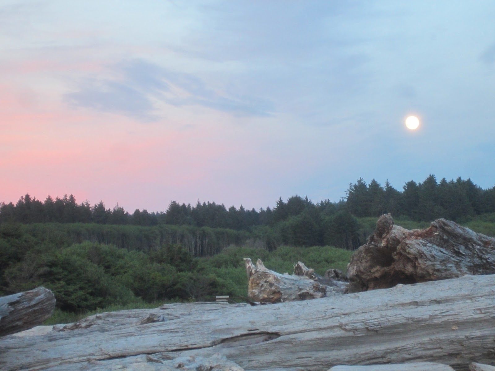 Once I was back on the road, I headed south. It was getting
a little late, and there was rain forecast for the evening, so I decided, by
looking at the map, to camp at Mora Campground on the coast and save the
rainforest for the next morning. What an intuitive decision – it was one of the
best I’ve made so far on the trip.
Once I was back on the road, I headed south. It was getting
a little late, and there was rain forecast for the evening, so I decided, by
looking at the map, to camp at Mora Campground on the coast and save the
rainforest for the next morning. What an intuitive decision – it was one of the
best I’ve made so far on the trip. The beach was lovely. There was a big garden of driftwood –
for lack of a better term – that I needed to walk through before getting to the
open sand, and the shapes and textures were compelling. But the ocean. There is
nothing quite like the Pacific Ocean of the Northwest. The water was cold of
course – too cold for swimming but not the dipping of toes – and watching the
waves come in, crashing on the sand, is always mesmerizing. There were a few
outlying islands, and they ended up being the perfect skyline for the setting
sun.
The beach was lovely. There was a big garden of driftwood –
for lack of a better term – that I needed to walk through before getting to the
open sand, and the shapes and textures were compelling. But the ocean. There is
nothing quite like the Pacific Ocean of the Northwest. The water was cold of
course – too cold for swimming but not the dipping of toes – and watching the
waves come in, crashing on the sand, is always mesmerizing. There were a few
outlying islands, and they ended up being the perfect skyline for the setting
sun.  There were clouds to the south, and the universe cooperated
with providing some sort of invisible boundary that held them at bay. There
were just a few that began encroaching on the sun, providing the multiple hues
and textures for one of the most amazing sunsets I’ve ever seen. The sky kept
shifting into deepening hues of oranges, pinks, and reds, and I snapped picture
after picture trying to capture the magnificence of the sky.
There were clouds to the south, and the universe cooperated
with providing some sort of invisible boundary that held them at bay. There
were just a few that began encroaching on the sun, providing the multiple hues
and textures for one of the most amazing sunsets I’ve ever seen. The sky kept
shifting into deepening hues of oranges, pinks, and reds, and I snapped picture
after picture trying to capture the magnificence of the sky.  Once back at camp, I attempted to make a fire, but the wood
I had bought was damp or green, and building a fire in a damp fire ring with un-aged
and damp wood is beyond my skill level. I fought it for a while and had a bit
of a blaze, but not enough to cook over. Little did I know that that would be
the last successful campfire I would have for a number of days.
Once back at camp, I attempted to make a fire, but the wood
I had bought was damp or green, and building a fire in a damp fire ring with un-aged
and damp wood is beyond my skill level. I fought it for a while and had a bit
of a blaze, but not enough to cook over. Little did I know that that would be
the last successful campfire I would have for a number of days. 


 I drove to the rainforest, and appropriately, it continued
raining. The drive was lovely, and I stopped occasionally to snap some
pictures. Once at the rainforest, I decided to hike two of the park’s short
interpretive trails, and it took me quite a while as I enjoyed the information
and the lush, wonderful landscape. I visited with a mother and son who were
here from Canada and Great Britain respectively, and we hike a little of the
way together. The rain was light, and my rain jacket and hat were plenty for
keeping me comfortable.
I drove to the rainforest, and appropriately, it continued
raining. The drive was lovely, and I stopped occasionally to snap some
pictures. Once at the rainforest, I decided to hike two of the park’s short
interpretive trails, and it took me quite a while as I enjoyed the information
and the lush, wonderful landscape. I visited with a mother and son who were
here from Canada and Great Britain respectively, and we hike a little of the
way together. The rain was light, and my rain jacket and hat were plenty for
keeping me comfortable. 

 After the rainforest, I continued south to Oregon. To cross
into Oregon, I took the four-mile long bridge that runs into Astoria. It was
raining, but the experience was still stunning as I drove what seemed for ages
over water. Once into Oregon, I headed for the first campground that appeared
to be right on the beach.
After the rainforest, I continued south to Oregon. To cross
into Oregon, I took the four-mile long bridge that runs into Astoria. It was
raining, but the experience was still stunning as I drove what seemed for ages
over water. Once into Oregon, I headed for the first campground that appeared
to be right on the beach. 


I'm so glad you got to see the peninsula! Next time you come out, plan on spending at least a week (maybe two) out there. I'll give you a longer list. :P Make it late July or August, and you'll have sunnier and warmer weather. It looks like you did the Hall of Mosses trail. Gorgeous pictures! :)
ReplyDelete