Monday, May 27, 2013

Day 7 – May 26 Fisher Towers and Star Trek


I left the campground where I’d been staying the past four nights this morning and moved closer to Moab. I wanted to do a few hikes north of town these last few days I’m here before I move west. Because it’s Memorial Day weekend, I was a little unsure how easy it’d be to find another campsite, but I figured it would all work out right. And it did.

I headed up 128, north from Moab, because I knew there were a lot of BLM campgrounds along that road. Last year, Jesse, Deb, and I found a really lovely campsite right on the Colorado River with shade trees and no red sand.  Not that I don’t love red sand, but I’d had about enough of it in my stuff for a while. When I broke camp this morning, I dumped the tent over to get rid of all the sand in it.

Speaking of breaking camp this morning, I got a very early start, thanks to my neighbors last night. A new group of campers came in while I was out doing my thing last night (which was sitting on the main drag, eating Gelato, people watching, and using the free wifi), and when I got back it was dark. I quickly made a fire and sat, writing my blog entry for yesterday, and listened to the group of adults and kids talking. They were up till midnight, talking loudly and making no attempt to keep quiet. This is unusual in my experience. Most people respect the quiet rules at campgrounds, keeping the noise and conversation level low from about 10 p.m. to 8 a.m. Not my new neighbors. Not only did they keep it going pretty loudly till midnight, but they were up, visiting and laughing before 6 a.m.

Now I’m a pretty tolerant person most the time, but this morning I wanted to yell for them to shut the hell up. I wished I had gotten my ear plugs out of the car the night before, and I went and got them about 6. I did lie there a few more minutes, but finally decided I might as well get up. So I was on the road to Moab and to hunt for a campsite by 7 a.m.

Of course, things work out like they’re supposed to, so my early start enabled a good campsite find. I tried the first few along the Colorado, and they were full. I thought I might as well check where we stayed last year, and what do you know – the campsite next to the one we had had just been vacated. I quickly snatched it up and set up camp before heading out to my hike. So I guess I should thank rather than curse my noisy neighbors this morning.

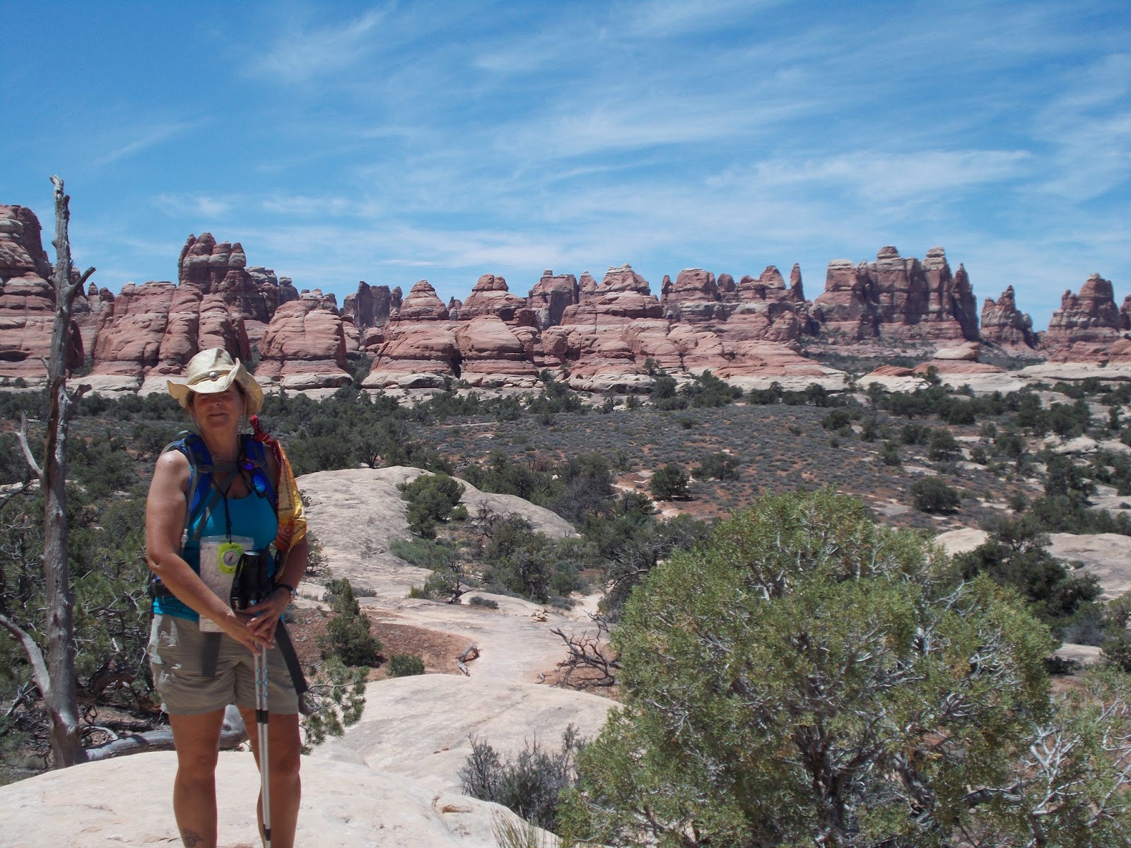
I hiked Fisher Towers today, at the recommendation of Joe the camp host. It was a wonderful suggestion. The spires and walls of rock were stunning, and the hike takes you right up against them. And there were some climbers there too, summiting the tall, craggy spires. I stood mesmerized, watching them scale the heights and then, on the return trip, watching them rappel down. If I were younger . . .

The hike led over and through some saddles and crevasses – in one place a ladder had been installed to assist with getting from one side of a crevasse to another.  I couldn’t help but think of the time, maybe 15 years ago, that I sat atop a 10 foot ladder and cried, afraid to descend it. Look at me now, would ya?

The day was not all great – when I got back into the car after the hike, I pulled out my camera to look at the pictures. I had lost almost all of them. I’m not sure what happened, and I’m going to visit with Jesse to see if knows if there was something I did wrong, but I’ll certainly check that they’re recording more regularly. I do have a few, but the one of the climber on top of the spire is gone. I have some of him descending, but that first one was a great shot. A bit far away for my little point and shoot, but you could still see him. (Update: The pictures showed up on the computer when I copied them – I still can’t see them on the camera, but I’m so happy they showed up. Perhaps it’s time for a new memory card.)


I’m also a little lonely today. With it being a holiday weekend, everyone is out celebrating with their friends and loved ones, and being alone is harder when you see so many enjoying each other. The first ten days were tough for me last year too, so hopefully I’ll settle into the solitude more comfortably as time goes on.

I alleviated some of the feeling of loss by escaping into story and air conditioning. Since I’ve recently become a Trekkie and am watching the original Star Trek series for the first time, I’ve been excited to see the new ST movie. So I bought myself a ticket, some popcorn and M&Ms, and had a great time watching Kirk and Spock, Bones, and all the rest of the crew recreated. It was just what I needed. Sometimes, a familiar face, even a fictional one, can bring a sense of companionship and connection.

Tomorrow I’m taking an easy day of hiking – just a short, three-miler to Corona Arch – before spending the rest of the day planning my next destination. I have a week to fill before I meet a backpacking partner at Capitol Reef next Sunday, and I’m not sure where exactly I’m headed. I do know it’s time to move on.  I love Moab and this area, but new vistas await, and I’m eager to be off.

Sunday, May 26, 2013

Day 6 – May 25 Needles and Needles


I really wasn’t sure how today was going to go. I was a little trigger shy after yesterday’s hike, and I wasn’t too eager to feel that kind of anxiety again. So I delayed my hike more than usual.

I headed south to the Needles District again, with teeth-gritting determination to hike the area once more. The hike I had decided to attempt was highly recommended by my campground host, Joe, who is a 70-something hiker himself. My book of hikes gave a number of options for this route, and distances and levels of difficulty ranged from 5 miles to 15 miles and easy to challenging. I knew I was shooting for both the shorter distance and the less challenging routes, but I hadn’t decided for sure what I was going to choose when I was out on the trail.

Hiking buddies Julie and Shinkai
I got about halfway to the trail head, maybe 30 miles down the road, and I decided to turn around and head to Moab to check for some mail I’m expecting. I wasn’t sure I wanted to do this hike and I needed some more time to decide.

Early-morning Moab was lovely, bustling with activity for the Memorial Day weekend with people gassing up off-road vehicles and filling ice coolers. It’s amazing here how many vehicles are 4-wheel drive and how many of those 4-wheel drive vehicles have gas cans strapped to their roofs or bumpers. Many of the locations for off-roading here require more gas to get to than fits in a gas tank.

The weather was perfect in the low 70s with a gentle breeze. I felt clean and perfectly comfortable, and I couldn’t help thinking how a multi-hour hike was going to change all that. I thought about choosing a different hike – one on the north side of Moab instead of back to the south, and I thought about revising my plans for the next few days, depending on whether my letter was here on not. The letter was not here, so I knew I had to stay close to Moab to pick it up Tuesday morning. Once I knew that, I decided to head back where my day began, and I traveled back south to The Needles District once more.

This trail left from a different trail head than the one from yesterday – one accessed only by a single-lane gravel road. But the remote location didn’t deter everyone; the parking lot for the trail head was full because in addition to the foot trail, there is a 4-wheel drive trail leaving from the same area.

Because I had delayed my start, it was noon before I was off and hiking. I immediately met two girls who were leaving at the same time, Julie and Shinkai. These were lovely young women, and we hiked much of the time together. Surprisingly, they both had gone to school at the University of Iowa. Shinkai was still in Iowa City working, but Julie had escaped Iowa and was living in Colorado. It was great hiking with them – I enjoy the solo hiking, but it’s nice to have company some of the time.

We hiked about two miles of the trail together until they decided to add in Druid Arch. They invited me to join them, but I decided to simply hike the shorter option, to a place called Chesler Park. The hike took me up many rock formations, but these had more gradual slopes for the most part, and a lot of the uphill hiking was climbing boulders and rocks. This, although strenuous, is much less nerve-wracking hiking – at least for me.

I saw a lot of other hikers along this trail – it’s one of the more popular apparently. And with it being a holiday weekend, the park was busy. But of course, busy is a relative term – I probably saw 25 – 30 hikers in the almost 6 miles I hiked.  And almost everyone is friendly and has an interesting story if you’re able to stop long enough to exchange pleasantries. The summit of the hike was on top of another saddle, and after the climb, it offered amazing views of Chesler Park, a flat meadow of sorts in the middle of the rock formations from which the district gets its name.

These Needles are truly breath-taking. They shoot up out of the ground in groups and individually. This is one of the most amazing terrains I’ve ever seen. Everywhere you look, there’s something to astonish these mid-western eyes. The colors, while somewhat monotone, are gorgeous in their oranges and golds and browns. And the variety of shapes is endless. One of the most memorable thing about this landscape is the layer
of spectacle. In some views, the La Sal Mountains stand at the horizon, and between these still snow-capped mountains there are various formations and vegetation – almost creating a visual overload. I could see this landscape inspiring someone to want to become a photographer – capturing the effect would be quite a feat.

Well, and then there's this.
When I returned to my car at 4:00, hot and sweaty and tired, I was so glad I’d decided to do the hike. I can’t imagine missing this – it has to be the highlight of Canyonlands, if not for everyone, it certainly has been for me. I agree with what I read in one of the pieces of literature about the place:  that until we can travel to Mars to see an other-worldly landscape, at least we have The Needles.

Saturday, May 25, 2013

Day 5 – May 24 Slickrock and Sand


Today was another day of hiking. I decided to hike in the Needles District of Canyonlands, and headed for what seemed like a decent hike – 7.3 miles and categorized as easy – moderate. The route hiked down Big Spring Canyon, crossed a saddle, and then up Squaw Canyon. Sounded great.

I decided to carry my loaded pack for the training experience, and set out on the hike. In the first ½ mile, I had to climb up a slickrock formation and back down it. I was surprised and a little unstable on the climb, but was pleased I could do it.

Crossed just left of the outcropping
As I continued, the trail occasionally crossed slickrock, and I enjoy that kind of hiking. At least I thought I did. There were many places where, like during yesterday’s hike, that the trail was marked only by cairns. I was very glad for the experience, and was better at spotting the cairns up ahead of where I was, directing my steps and route.
Looking up at where I need to go

When I read about this hike, the literature had mentioned that if someone was afraid of heights, they might have trouble with a small portion of the hike. Yes. I’m agreeing with that assessment, and I’m really glad I’ve gotten over my fear of heights. I wouldn’t have been able to make it through the roughest part of the hike.

Up the rabbit hole - climbing up this was maybe the scariest
After about three miles, quite a bit of which was over slickrock, I came to the saddle. This is a lower place on some rock walls to cross from one canyon to the other. To get up and over the saddle, I had to climb some steep slickrock and walk across it at a steep angle. One mis-step and I would slide to the rocks below. I also had to climb up where there were almost no places to place my feet. I was very grateful I’d had the rock-climbing lesson last year – I kept thinking, “take your time and lean into the wall.”

It’s hard to explain the sensation of walking on a steep incline, sure your feet will slip down and out from under you, and instead your boots stick to the rock. Trusting that, and knowing when it’s too steep to grab, is more intuitive and trial and error than any logical reasoning I can figure out. And having done so little of it (we did some last year at Arches and down in the Superstition Wilderness), I’m very unsure of my judgment.

View from the top of the saddle
When I got to the crest of the saddle, my heart was pounding and I felt a little nauseated and dizzy. I stood there, trying to catch my breath, and another hiker came from the other side. He said, “I bet you didn’t expect to find someone else here.” I said no, but I was happy to see him.

We both sat, and we talked for about 30 minutes. He was an interesting guy – he travels a lot and had recently returned from Bolivia, and he was on the last day of a week of backpacking in here in Canyonlands. It helped so to talk with another human being at that moment, and to get some good rest before tackling the descent. It’s funny how just what we need seems to show up when we need it.

Ready to descend - you can see the cairns showing the way down in bottom right
Coming down off the saddle was tricky, but I felt better after being successful with the ascent and after talking to Dave. The trickiest part of the descent was navigating a drop where some wonderful ranger or hiker had actually notched the rock  - this way, one could get down or up without having to drop (or climb) 10 feet.

Once I was off the slickrock, the trail became a sandy path along the bottom of the canyon. The air was hot and the sand loose and thick, so the going was a bit ponderous. I counted every step that last few miles, cursing myself for not bringing a hat and forgetting to put on sunscreen. Finally, I was within a mile of the car, and came upon one more section of slickrock to climb to get out of the canyon. By that time, I was probably more careless than I should have been, simply out of fatigue. But I finished without incident, and was soon in the cool air conditioning in my car.

And down the rabbit hole
Across and down the slickrock - you can just see the notches in the rock just left of center in the depression
As I drove out of the parking area, I wondered why in the hell I do this. I was miserable – hot, exhausted, anxious. And I knew I was going to do it again. This kind of hiking is hard with the heat and precarious terrain, but hiking 220 miles this July, with 46,000 feet of ascent and 42,000 feet of descent won’t be a walk in the park either. This is a pastime that demands a little bit of insanity I think.  I was having a sane moment after this hike, questioning my decision to keep at it and wondering if I’d feel like taking another walk tomorrow.

But a few hours later, I began wondering which hike I was going to take in the morning. I realized it’s a lot like getting a tattoo – when you’re going through it, it’s miserable and you think you’ll never do it again. But then within a short time you’re looking for that next picture to put in your skin and wondering where you’ll put it. Or maybe it’s like having a baby – when you’re going through labor, you can’t imagine doing it again, but then you quickly forget how hard it was and are ready to do it all over again.

So, choose your metaphor, but I’m going at it again tomorrow. Who knows what will happen, but I know it will be memorable.

Friday, May 24, 2013

Day 4 – May 23 First Hike – Dead Horse Point


Lunch at the top of the world

I awoke with the sun this morning – just after 6 a.m. My night’s sleep was occasionally disturbed by strong winds pushing the tent wall against me. I’m happy to report that the tent apparently is well-designed for strong winds.


I dressed and headed for Dead Horse Point, forgoing a cooked breakfast. I have yet to cook in the morning although I have eggs in the cooler. I just can’t seem to get fired up to make the time to do that. There’s something about breakfast needing to be shared, and the idea of cooking it for myself just holds no power. So I grabbed a protein bar to eat on the way.
Met a couple with whom I exchanged photography duties

By the time I arrived at the trailhead, it was a little after 8, and I had to go in and get a map, pay my park entry fee (this is a state park, so my National Park Pass won’t work), and ask a few questions about the trails.
 
It felt good to be back on the trail. I didn’t get a lot of hiking in this spring with the late snow and un-spring-like weather, and the conditioning I did was mostly in the gym. And it’s been since last summer, when we hiked the Grand Canyon and at Arches, since I’ve been on slickrock and sand in the heat. I love this kind of hiking – I’m not sure why. Maybe it’s because the first real hiking I ever did was when Jesse and I hiked The Wave just a little south of here. That’s where I fell in love with hiking, and I suppose we often come back to that first experience with affection.

This was a good hike to start the season with. The book I bought on the area called this a moderate hike but one that didn’t have a lot of elevation gain or loss. The trail was mainly a loop, with a number of little side hikes to overlooks. I thought I’d make all the overlook side trips and hike about nine miles. I didn’t quite do that, but I got seven good miles in.

The hike was breathtaking as it overlooked some of the canyons carved out by the Colorado River. It provided a good look at the river, and it also offered a good view of the famous Horseshoe Bend where the river makes as a u-turn in its wanderings. The big views were complemented by the occasional wild flower and the weathered trees and stone formations. Some of the stone formations were man-made in the form of cairns, marking the way. These cairns were a life-saver. During the first half of the hike, along the eastern rim, the trail was easy to follow (although I did start out the wrong direction immediately and had to back track after about 10 minutes when I realized what I had done). There were just a few places that I lost the trail for a few moments. But the second half of the trail, along the west rim, was much more difficult to follow, and it was important to watch for these cairns. I’m grateful for the rangers who maintain the markers, keeping us on track.
 
After a few miles, I began to get my Southwest hiking wits about me. This is very different hiking from well-defined trails found through forests and areas that have clear pathways. Much of the hiking in the canyon country here is over slickrock, stepping – or climbing – up over boulders and around outcroppings. There is no way to identify the trail much of the time, except for these cairns and sometimes a slight discoloration from the wear patterns where others have walked. I began to scan the area in front of me, bringing in a wider area, panning across my line of sight and looking ahead farther for a cairn I might spot a bit farther up the trail. It’s easy to be hiking along, and suddenly find yourself off the trail. The path has turned, but the only indication is a cairn or so off in the other direction.

About halfway into the hike, I realized my feet were beginning to hurt a little. I’ve been working all spring with my podiatrist and a postural physical therapist to recover from the plantar fasciitis I got late last fall. My foot is much better, but it still is tender, and when I start to rack up the miles, I notice it more. It suddenly occurred to me that I may never again be pain-free on my right foot. It also occurred to me that I can handle that. The pain is not acute, and I can live with it. I certainly don’t want to give up hiking because of it.

As I’m walking along, thinking about this pain and how I’ve worked at getting healed for this summer, I realized, once again, how fortunate I am. I have health insurance. If I hadn’t had health insurance, I wouldn’t have been able to afford the doctor or the therapist. And I thought about how many people, who don’t have insurance, just have to live with something like this. I’m especially aware of what being able to go to my physical therapist means for my life and for my future. She’s worked to correct the way I walk, the way I carry myself, the way I use my muscles (or don’t use them). Because of what she’s done to educate me and correct those things, I should be able to stay active and able to do the things I want for many more years. So many people, as they age, begin to have all these physical conditions that limit their lives. And I think of how few of those people know they can get some good help on correcting those things by seeing someone like my therapist. And how many of those people, even if they knew about the help a physical therapist could give them, couldn’t afford her because of the lack of insurance.

It’s an unfair world, no doubt about it. I feel so fortunate that I have so much – and I don’t mean things. I mean opportunity. Opportunity that’s often invisible. When the sociologists talk about invisible privilege, these are some of the privileges they’re talking about. It saddens me that we live in a world where only a few can have the resources to make their lives fuller and longer. It also saddens me that so many people simply accept this imbalance, even believe it’s necessary.  Some believe we should have to earn the right to have comfort, abundance, and joy.  But how many of us really have “earned” this right? So often these are gifts that are bestowed upon us by forces outside our own power – who our parents are, what color our skin is, what kind of socioeconomic environment we come from. Yes, I went to school and got a job that provides health insurance. But circumstance provided that opportunity – a circumstance not everyone has.

So as I figure out how to be more comfortable hiking, so many are figuring out how to pay for medicine, or feed their children, of find a job. I really believe our obligation, as privileged human beings, seems to be to learn to bring those less fortunate along – to help provide the opportunities we enjoy to those without them. How do we do that?  Again, it might be as it is with so many things – we need to keep our eyes open and act when the opportunity arises.